Stephanie Norby's collections
American Authors and Innovation
Choose one of the American authors in this collection. Research the author and read some of his or her writings. Write a short persuasive essay arguing whether or not this author was innovative and if so how. Discuss whether or not innovation is important in determining the strength of a writer's work.
Analyze the portrait of your author using the portrait handout. Does the portrait capture the qualities that made this author innovative? If not, how would you change the portrait to capture these qualities?
 Stephanie Norby
48
The Wright Brothers -- Invention or Innovation?
This is a teaching collection about the Wright Brothers and their invention process. What is the difference between innovation and invention?
Stephanie Norby
12
Innovations and Milestones in Flight
This teaching collection includes a teaching poster, website, video, and digital images about the six milestones of flight.
Stephanie Norby
11
American Inventions and Innovation
Read an article about the opening of the "American Inventions" exhibition in the National Museum of American History. Examine some of the artifacts featured in the exhibition and select one that you believe had the greatest impact. Write a persuasive essay on why this invention is so important.
Stephanie Norby
12
Innovations in Coffee Cup Lids
Sometimes innovations are about something completely new and sometimes innovations are about small refinements in design. What can we learn about innovation from looking at something as ordinary as a coffee cup lid? Read the article about coffee cup lids and write a description for one of the lids, capturing its unique qualities. How do changes in coffee cup lids reflect larger changes in our society? Predict what will be the next innovation .
Stephanie Norby
57
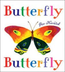
Butterfly Diversity and Innovation in Nature
This is a collection that shows many different types of butterflies. Why do butterflies vary? What are the processes in nature that result in biodiversity? How is this process different from innovations created by people?
Stephanie Norby
21
Clovis Points and Early Innovation in North America
Clovis points were an American invention, perhaps the first. More than 10,000 Clovis points have been discovered scattered in 1,500 locations throughout North America, dating back 13,000 years. This teaching collection includes: 1) a 3-D scan of a Clovis point; 2) a video of Smithsonian anthropologist Dr. Dennis Stanford explaining what they tell us about early America, 3) a video demonstration of how stone tools were made; and 4) three Smithsonian magazine articles about Clovis points and stone tools.
Stephanie Norby
7
Earth From Space: Using Satellite Images to Understand Our Planet
Satellite images help us to observe trends and to better understand our planet -- the rise and fall of water levels, the growth of urban centers, the path of forest fires. This teaching collection includes: 1) Earth From Space, a recorded online session with Andrew K. Johnson, a geographer at the National Air and Space Museum; 2) Reflections on Earth, a poster and lessons on how to use satellite images to investigate changes over time and how to use scale to calculate distance and area; 3) three sets of satellite images to practice these skills -- on flooding, urbanization, and forest fires; 4) a video about satellite technology, and 5) a video about an interactive globe (Tangible Earth).
Stephanie Norby
11

Looking at Earth: Seeing Africa from Above
Throughout history we have sought to better understand our world by viewing it from above. We first climbed trees, hills and fortress towers to observe the lay of the land. Today, aircraft and spacecraft look down on Earth to predict the weather, survey the terrain, monitor crops and forests, plan cities, locate resources, and gather intelligence.
This teachers guide and student activity includes an online exhibition, Looking at Earth, with background information on aerial imagery and aerial photographs of towns and cities in Africa. Divide students into small groups and ask each group to examine a different photograph responding to the following statements or questions: 1) Describe the physical (natural) features in the photograph. 2) Describe the human-made characteristics. 3) Identify the ways in which people use the land. 4) Do the streets form a grid or some other pattern? 5) Identify regions within the photograph defined by the ways in which the land is used (residential, commercial, industrial, recreational, transportation).
Ask each group to share their findings with the entire class. Discuss how the African towns and cities are different and the role of geography in defining a place. Locate the different towns and cities on a map of Africa.
Stephanie Norby
17
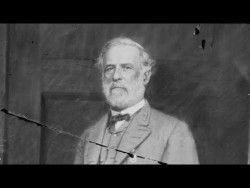
A House Divided: Photography in the Civil War
How does photography of the Civil War inform us about this period? This teaching collection includes the lesson plan, A House Divided: Photography of the Civil War, published by the Smithsonian American Art Museum. Students examine Civil War photographs, write captions, and discuss how viewing photographs enhances your understanding of historical events and concepts.
Stephanie Norby
9
Mapping the Past: Using Technology to Understand the Battle of Gettysburg
This teaching collection and student interactive are about applying cutting-edge technology to inform our understanding of what happened at the Civil War Battle of Gettysburg in 1863. Ask students to watch the video, read the article and use the interactive to see the impact of geography on the final outcome of the Battle.
Stephanie Norby
3
Abraham Lincoln's Life: Looking at Personal Artifacts
What do personal possessions tell us about a person? This teaching collection includes: 1) artifacts that belonged to President Lincoln, 2) a handout to guide analyzing artifacts as primary sources, 3) a video of Harry Rubenstein, a historian at the National Museum of American History, telling about the objects, and 4) two videos of Harry Rubenstein describing how he verifies the history of objects.
Stephanie Norby
11
The Civil War and American Art
These videos use the best artworks, by some of the greatest American artists, to reveal what life was like during the Civil War. The artists explore the emotional meaning of these events. Eleanor Jones Harvey, the chief curator at the Smithsonian American Art Museum, produced five, short (2-3 minute) videos, each one examining a different artwork from this period. In addition, this teaching collection includes images of the artworks and artists, recommended discussion questions, writing prompts, and detailed lesson plans in The Civil War and American Art: Teachers' Guide, Smithsonian American Art Museum, 2012.
Stephanie Norby
15

Seeing the Civil War through Different Perspectives Using Photographs
A carte de visite is a photograph the size of a visiting card, and such photograph cards were traded among friends and visitors and saved in albums. This teaching collection includes carte de visites of people who lived during the Civil War. The purpose of the collection is to consider their different points of view and experiences. Each student receives a different carte de visite and researches that person. During classroom discussions of Civil War events, students comment from the perspective of the person they researched.
Stephanie Norby
41
